North Sydney night lights from space
Night Light of North Sydney (New South Wales) from space (Australia) Src. Average luminocity for 10x10km area is 82.5175% and for 50x50km: 41.3417%.
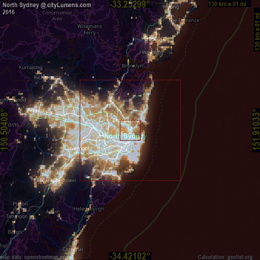
Analysis of North Sydney night lights 2016
Square area 10x10 km:
 26.4%
26.4%90-99
21.15%80-89
5.59%70-79
20.98%60-69
16.78%50-59
4.37%40-49
3.5%30-39
1.22%20-29
0%10-19
0%0-9
0%Square area 50x50 km:
9.79%90-99
10.47%80-89
5.11%70-79
6.61%60-69
7.98%50-59
3.63%40-49
2.41%30-39
3.58%20-29
4.89%10-19
7.67%0-9
37.87%Clear (daylight) street map image can be seen on geolist.org.
Map coordinates:
33° 15' 10.8" South, 150° 30' 14.7" East
33° 50' 20.4" South, 151° 12' 25.9" East
34° 25' 15.7" South, 151° 54' 37.2" East
Some cities around North Sydney sort by population:
• Cremorne
2.2 km =1.4 mi,  52°
52°
• Balmain
2.8 km =1.7 mi,  231°
231°
• Neutral Bay
1 km =0.6 mi,  82°
82°
• Wollstonecraft
1.7 km =1.1 mi,  293°
293°
• Cammeray
2.1 km =1.3 mi,  22°
22°
• St Leonards
1.9 km =1.2 mi,  334°
334°
• Greenwich
2.2 km =1.4 mi,  268°
268°
• Naremburn
2.5 km =1.6 mi,  346°
346°
2154855 (p: 8,055)
Sources (retrieved 2019-11-25):
» Earth at Night: Flat Maps 2012, 2016