Wollstonecraft night lights from space
Night Light of Wollstonecraft (New South Wales) from space (Australia) Src. Average luminocity for 10x10km area is 83.4615% and for 50x50km: 43.1085%.
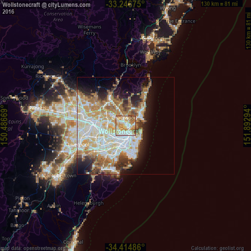
Analysis of Wollstonecraft night lights 2016
Square area 10x10 km:
 21.68%
90-99
22.55%80-89
12.06%70-79
22.73%60-69
14.86%50-59
4.55%40-49
1.57%30-39
0%20-29
0%10-19
0%0-9
0%Square area 50x50 km:
10.31%90-99
11.18%80-89
5.56%70-79
6.74%60-69
7.94%50-59
3.7%40-49
2.44%30-39
3.57%20-29
4.93%10-19
7.76%0-9
35.86%Clear (daylight) street map image can be seen on geolist.org.
Map coordinates:
33° 14' 48.3" South, 150° 29' 12.1" East
33° 49' 58.1" South, 151° 11' 23.3" East
34° 24' 53.5" South, 151° 53' 34.6" East
Some cities around Wollstonecraft sort by population:
• Balmain
2.5 km =1.6 mi,  193°
193°
• Neutral Bay
2.6 km =1.6 mi,  102°
102°
• Artarmon
1.9 km =1.2 mi,  341°
341°
• North Sydney
1.7 km =1.1 mi,  113°
113°
• Cammeray
2.7 km =1.7 mi,  62°
62°
• St Leonards
1.3 km =0.8 mi,  37°
37°
• Greenwich
1 km =0.6 mi,  220°
220°
• Naremburn
2 km =1.2 mi,  29°
29°
9972972 (p: 8,329)
Sources (retrieved 2019-11-25):
» Earth at Night: Flat Maps 2012, 2016