Mosman Park night lights from space
Night Light of Mosman Park (Western Australia) from space (Australia) Src. Average luminocity for 10x10km area is 60.4808% and for 50x50km: 40.0364%.
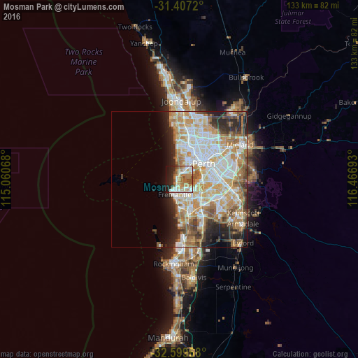
Analysis of Mosman Park night lights 2016
Square area 10x10 km:
 13.11%
90-99
12.59%80-89
8.74%70-79
6.99%60-69
17.13%50-59
5.07%40-49
6.64%30-39
0.7%20-29
13.64%10-19
13.46%0-9
1.92%Square area 50x50 km:
9.37%90-99
10.08%80-89
4.77%70-79
6.39%60-69
7.71%50-59
4.18%40-49
3.07%30-39
2.84%20-29
5.95%10-19
5.36%0-9
40.27%Clear (daylight) street map image can be seen on geolist.org.
Map coordinates:
31° 24' 25.9" South, 115° 3' 38.4" East
32° 0' 19.4" South, 115° 45' 49.7" East
32° 35' 58.8" South, 116° 28' 0.9" East
Some cities around Mosman Park sort by population:
• Nedlands
4.9 km =3 mi,  57°
57°
• Claremont
3.4 km =2.1 mi,  31°
31°
• East Fremantle
3.7 km =2.3 mi,  174°
174°
• Cottesloe
1.3 km =0.8 mi,  336°
336°
• Palmyra
4.9 km =3 mi,  154°
154°
• Bicton
3.1 km =1.9 mi,  143°
143°
• Attadale
4.2 km =2.6 mi,  121°
121°
• Melville
5.2 km =3.2 mi, 137°
2065710 (p: 8,566)
Sources (retrieved 2019-11-25):
» Earth at Night: Flat Maps 2012, 2016