Claremont night lights from space
Night Light of Claremont (Western Australia) from space (Australia) Src. Average luminocity for 10x10km area is 64.8007% and for 50x50km: 41.2316%.
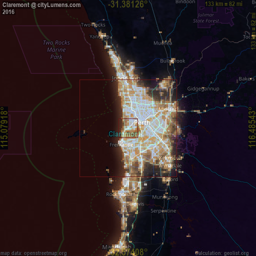
Analysis of Claremont night lights 2016
Square area 10x10 km:
 12.76%
90-99
10.66%80-89
8.92%70-79
9.27%60-69
22.73%50-59
8.74%40-49
8.04%30-39
0.52%20-29
13.81%10-19
4.55%0-9
0%Square area 50x50 km:
9.32%90-99
10.19%80-89
4.98%70-79
6.63%60-69
7.83%50-59
4.45%40-49
3.34%30-39
3.31%20-29
6.45%10-19
6.67%0-9
36.83%Clear (daylight) street map image can be seen on geolist.org.
Map coordinates:
31° 22' 52.5" South, 115° 4' 45" East
31° 58' 46.6" South, 115° 46' 56.3" East
32° 34' 26.7" South, 116° 29' 7.5" East
Some cities around Claremont sort by population:
• Nedlands
2.4 km =1.5 mi,  96°
96°
• Subiaco
5.4 km =3.4 mi,  50°
50°
• Mosman Park
3.4 km =2.1 mi,  211°
211°
• Floreat
4.7 km =2.9 mi,  11°
11°
• Cottesloe
2.8 km =1.7 mi,  234°
234°
• City Beach
5.4 km =3.4 mi,  338°
338°
• Bicton
5.4 km =3.4 mi,  178°
178°
• Attadale
5.4 km =3.4 mi,  159°
159°
2078904 (p: 8,033)
Sources (retrieved 2019-11-25):
» Earth at Night: Flat Maps 2012, 2016