Melville night lights from space
Night Light of Melville (Western Australia) from space (Australia) Src. Average luminocity for 10x10km area is 82.0997% and for 50x50km: 40.9454%.
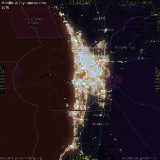
Analysis of Melville night lights 2016
Square area 10x10 km:
 20.1%
20.1%90-99
24.83%80-89
13.81%70-79
15.56%60-69
14.34%50-59
5.42%40-49
5.94%30-39
0%20-29
0%10-19
0%0-9
0%Square area 50x50 km:
9.3%90-99
9.98%80-89
4.72%70-79
6.01%60-69
7.94%50-59
4.77%40-49
3.46%30-39
3.36%20-29
6.52%10-19
7.51%0-9
36.42%Clear (daylight) street map image can be seen on geolist.org.
Map coordinates:
31° 26' 32.8" South, 115° 5' 52.9" East
32° 2' 25.4" South, 115° 48' 4.2" East
32° 38' 4.1" South, 116° 30' 15.4" East
Some cities around Melville sort by population:
• Kardinya
3.1 km =1.9 mi,  155°
155°
• East Fremantle
3.2 km =2 mi,  274°
274°
• Palmyra
1.5 km =0.9 mi,  250°
250°
• Applecross
4 km =2.5 mi,  48°
48°
• Bicton
2.2 km =1.4 mi,  309°
309°
• Attadale
1.7 km =1.1 mi,  2°
2°
• Winthrop
3 km =1.9 mi,  115°
115°
• Booragoon
3.1 km =1.9 mi,  88°
88°
8349390 (p: 5,583)
Sources (retrieved 2019-11-25):
» Earth at Night: Flat Maps 2012, 2016