Mooroopna night lights from space
Night Light of Mooroopna (Victoria) from space (Australia) Src. Average luminocity for 10x10km area is 22.0087% and for 50x50km: 1.9279%.
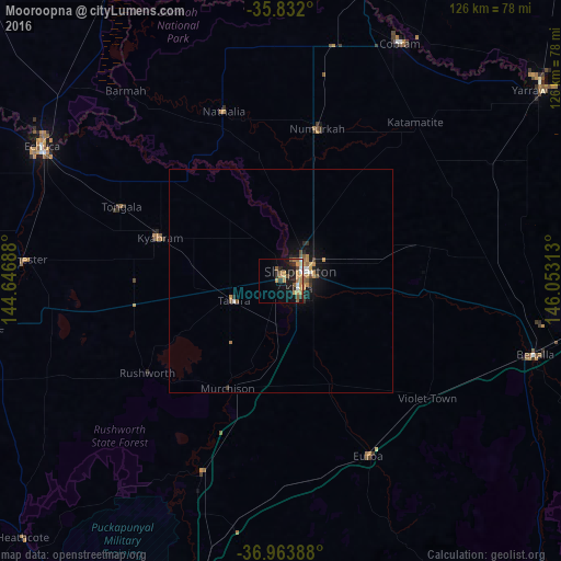
Analysis of Mooroopna night lights 2016
Square area 10x10 km:
 2.45%
2.45%90-99
1.05%80-89
1.57%70-79
7.34%60-69
4.02%50-59
4.9%40-49
1.4%30-39
2.97%20-29
5.24%10-19
16.78%0-9
52.27%Square area 50x50 km:
0.19%90-99
0.12%80-89
0.09%70-79
0.59%60-69
0.28%50-59
0.4%40-49
0.17%30-39
0.23%20-29
0.41%10-19
1.71%0-9
95.81%Clear (daylight) street map image can be seen on geolist.org.
Map coordinates:
35° 49' 55.2" South, 144° 38' 48.8" East
36° 24' 0" South, 145° 21' 0" East
36° 57' 50" South, 146° 3' 11.3" East
Some cities around Mooroopna sort by population:
• Shepparton
4.9 km =3 mi,  63°
63°
• Echuca
60.9 km =37.8 mi,  298°
298°
• Benalla
59.1 km =36.7 mi,  106°
106°
• Yarrawonga
72 km =44.7 mi,  54°
54°
• Kyabram
28.5 km =17.7 mi,  289°
289°
• Kialla
7.8 km =4.8 mi,  132°
132°
• Moama
62.2 km =38.6 mi, 301°
• Cobram
59.3 km =36.8 mi,  26°
26°
2156974 (p: 7,745)
Sources (retrieved 2019-11-25):
» Earth at Night: Flat Maps 2012, 2016