Landsdale night lights from space
Night Light of Landsdale (Western Australia) from space (Australia) Src. Average luminocity for 10x10km area is 63.9707% and for 50x50km: 33.3437%.
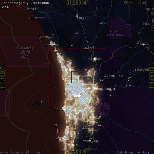
Analysis of Landsdale night lights 2016
Square area 10x10 km:
 14.29%
90-99
15.02%80-89
8.24%70-79
14.47%60-69
7.51%50-59
4.76%40-49
5.86%30-39
10.44%20-29
10.07%10-19
9.34%0-9
0%Square area 50x50 km:
7.7%90-99
8.17%80-89
3.15%70-79
4.49%60-69
6.38%50-59
3.7%40-49
2.45%30-39
3.31%20-29
5.65%10-19
9.01%0-9
45.98%Clear (daylight) street map image can be seen on geolist.org.
Map coordinates:
31° 12' 28.9" South, 115° 9' 46.3" East
31° 48' 27" South, 115° 51' 57.6" East
32° 24' 11.1" South, 116° 34' 8.8" East
Some cities around Landsdale sort by population:
• Ballajura
4.6 km =2.9 mi,  142°
142°
• Balga
5.8 km =3.6 mi,  205°
205°
• Marangaroo
3.4 km =2.1 mi,  230°
230°
• Girrawheen
4.5 km =2.8 mi, 213°
• Mirrabooka
5.8 km =3.6 mi,  180°
180°
• Alexander Heights
2.2 km =1.4 mi, 182°
• Darch
2 km =1.2 mi,  253°
253°
• Madeley
3.6 km =2.2 mi,  263°
263°
8349177 (p: 12,048)
Sources (retrieved 2019-11-25):
» Earth at Night: Flat Maps 2012, 2016