Alexander Heights night lights from space
Night Light of Alexander Heights (Western Australia) from space (Australia) Src. Average luminocity for 10x10km area is 78.6777% and for 50x50km: 35.346%.
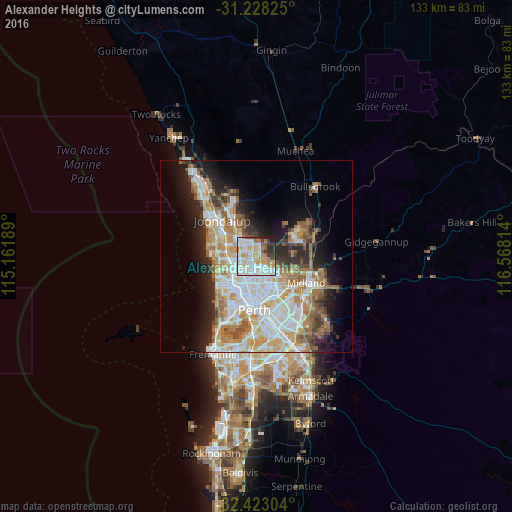
Analysis of Alexander Heights night lights 2016
Square area 10x10 km:
 23.99%
90-99
26.01%80-89
8.79%70-79
13%60-69
7.51%50-59
4.03%40-49
2.93%30-39
6.96%20-29
5.68%10-19
1.1%0-9
0%Square area 50x50 km:
8.21%90-99
8.72%80-89
3.77%70-79
5.07%60-69
6.39%50-59
3.69%40-49
2.46%30-39
3.28%20-29
5.78%10-19
8.87%0-9
43.75%Clear (daylight) street map image can be seen on geolist.org.
Map coordinates:
31° 13' 41.7" South, 115° 9' 42.8" East
31° 49' 39.3" South, 115° 51' 54" East
32° 25' 22.9" South, 116° 34' 5.3" East
Some cities around Alexander Heights sort by population:
• Ballajura
3.2 km =2 mi,  116°
116°
• Balga
3.9 km =2.4 mi,  217°
217°
• Landsdale
2.2 km =1.4 mi,  2°
2°
• Marangaroo
2.5 km =1.6 mi,  271°
271°
• Girrawheen
2.8 km =1.7 mi,  237°
237°
• Mirrabooka
3.6 km =2.2 mi,  178°
178°
• Darch
2.5 km =1.6 mi,  312°
312°
• Madeley
3.9 km =2.4 mi,  297°
297°
8348266 (p: 7,841)
Sources (retrieved 2019-11-25):
» Earth at Night: Flat Maps 2012, 2016