Ballajura night lights from space
Night Light of Ballajura (Western Australia) from space (Australia) Src. Average luminocity for 10x10km area is 71.2473% and for 50x50km: 36.6267%.
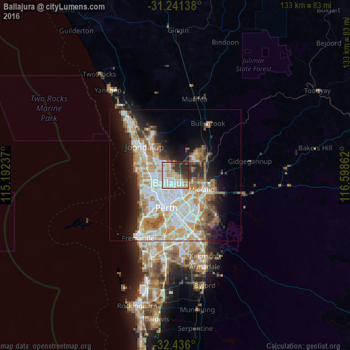
Analysis of Ballajura night lights 2016
Square area 10x10 km:
 17.95%
90-99
21.79%80-89
6.96%70-79
13.19%60-69
8.79%50-59
4.58%40-49
3.48%30-39
11.36%20-29
11.72%10-19
0.18%0-9
0%Square area 50x50 km:
8.53%90-99
9.19%80-89
4.11%70-79
5.29%60-69
6.41%50-59
3.72%40-49
2.51%30-39
3.26%20-29
5.89%10-19
8.82%0-9
42.27%Clear (daylight) street map image can be seen on geolist.org.
Map coordinates:
31° 14' 29" South, 115° 11' 32.5" East
31° 50' 26.2" South, 115° 53' 43.8" East
32° 26' 9.6" South, 116° 35' 55" East
Some cities around Ballajura sort by population:
• Morley
5.4 km =3.4 mi,  165°
165°
• Landsdale
4.6 km =2.9 mi,  322°
322°
• Beechboro
4.7 km =2.9 mi,  125°
125°
• Girrawheen
5.3 km =3.3 mi,  269°
269°
• Mirrabooka
3.5 km =2.2 mi,  232°
232°
• Noranda
3.7 km =2.3 mi, 174°
• Alexander Heights
3.2 km =2 mi,  296°
296°
• Bennett Springs
5.1 km =3.2 mi,  114°
114°
8348081 (p: 18,408)
Sources (retrieved 2019-11-25):
» Earth at Night: Flat Maps 2012, 2016