Kingsford night lights from space
Night Light of Kingsford (New South Wales) from space (Australia) Src. Average luminocity for 10x10km area is 86.7413% and for 50x50km: 36.9503%.
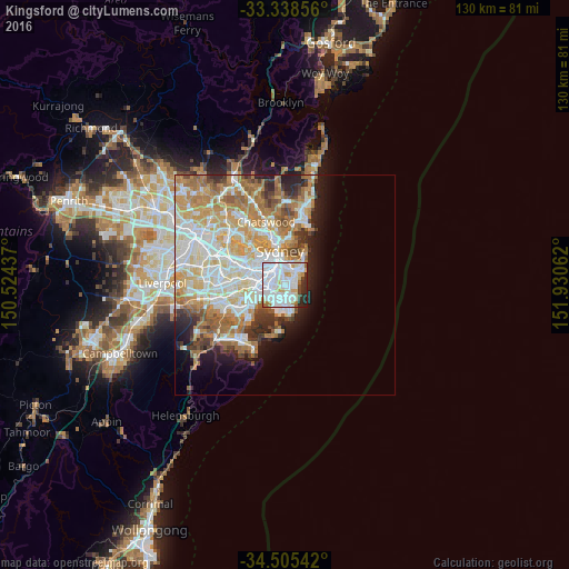
Analysis of Kingsford night lights 2016
Square area 10x10 km:
 43.71%
90-99
29.02%80-89
3.85%70-79
6.82%60-69
3.32%50-59
1.22%40-49
2.62%30-39
2.27%20-29
6.47%10-19
0.7%0-9
0%Square area 50x50 km:
8.98%90-99
9.54%80-89
4.64%70-79
6.08%60-69
6.92%50-59
3.33%40-49
2.24%30-39
2.96%20-29
3.61%10-19
5.33%0-9
46.37%Clear (daylight) street map image can be seen on geolist.org.
Map coordinates:
33° 20' 18.8" South, 150° 31' 27.7" East
33° 55' 26.4" South, 151° 13' 39" East
34° 30' 19.5" South, 151° 55' 50.2" East
Some cities around Kingsford sort by population:
• Randwick
2.2 km =1.4 mi,  61°
61°
• Maroubra
2.9 km =1.8 mi,  169°
169°
• Coogee
2.6 km =1.6 mi,  81°
81°
• Kensington
0.6 km =0.4 mi,  312°
312°
• Zetland
2.5 km =1.6 mi,  316°
316°
• Eastlakes
1.7 km =1.1 mi,  237°
237°
• South Coogee
2.7 km =1.7 mi,  106°
106°
• Hillsdale
3.1 km =1.9 mi,  179°
179°
6621337 (p: 15,338)
Sources (retrieved 2019-11-25):
» Earth at Night: Flat Maps 2012, 2016