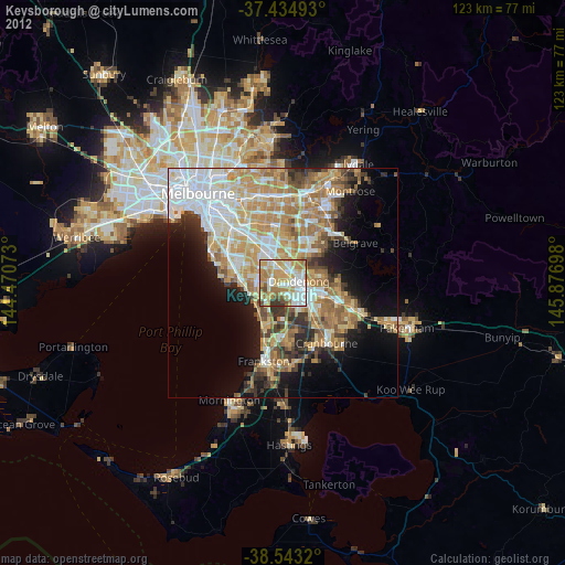
Keysborough night lights from space
Night Light of Keysborough (Victoria) from space (Australia) Src. Average luminocity for 10x10km area is 82.4789% and for 50x50km: 41.3669%.
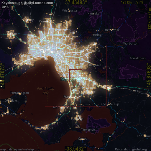
Analysis of Keysborough night lights 2016
Square area 10x10 km:
 22.24%
90-99
27.44%80-89
9.09%70-79
17.37%60-69
10.55%50-59
6.33%40-49
4.06%30-39
2.92%20-29
0%10-19
0%0-9
0%Square area 50x50 km:
10.1%90-99
8.83%80-89
4.2%70-79
7.25%60-69
6.99%50-59
5.71%40-49
3.67%30-39
3.74%20-29
5.58%10-19
9.43%0-9
34.5%Clear (daylight) street map image can be seen on geolist.org.
Map coordinates:
37° 26' 5.7" South, 144° 28' 14.6" East
37° 59' 28.2" South, 145° 10' 25.9" East
38° 32' 35.5" South, 145° 52' 37.1" East
Some cities around Keysborough sort by population:
• Noble Park
2.8 km =1.7 mi,  346°
346°
• Dandenong
2.5 km =1.6 mi,  69°
69°
• Dandenong North
4.1 km =2.5 mi,  47°
47°
• Springvale
5.1 km =3.2 mi,  338°
338°
• Springvale South
3.4 km =2.1 mi,  322°
322°
• Dingley Village
3.6 km =2.2 mi,  285°
285°
• Doveton
5.7 km =3.5 mi,  92°
92°
• Noble Park North
4.9 km =3 mi,  19°
19°
2161532 (p: 25,637)
Sources (retrieved 2019-11-25):
» Earth at Night: Flat Maps 2012, 2016