Dingley Village night lights from space
Night Light of Dingley Village (Victoria) from space (Australia) Src. Average luminocity for 10x10km area is 79.4594% and for 50x50km: 43.4921%.
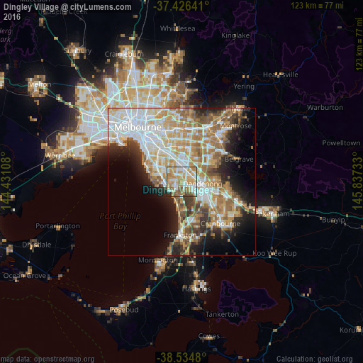
Analysis of Dingley Village night lights 2016
Square area 10x10 km:
 17.53%
90-99
22.73%80-89
9.9%70-79
22.08%60-69
13.47%50-59
7.79%40-49
2.92%30-39
1.3%20-29
2.27%10-19
0%0-9
0%Square area 50x50 km:
10.85%90-99
9.68%80-89
4.73%70-79
7.37%60-69
7.03%50-59
5.76%40-49
3.71%30-39
3.84%20-29
5.85%10-19
8.62%0-9
32.56%Clear (daylight) street map image can be seen on geolist.org.
Map coordinates:
37° 25' 35.1" South, 144° 25' 51.9" East
37° 58' 57.7" South, 145° 8' 3.1" East
38° 32' 5.3" South, 145° 50' 14.4" East
Some cities around Dingley Village sort by population:
• Noble Park
3.4 km =2.1 mi,  57°
57°
• Keysborough
3.6 km =2.2 mi,  105°
105°
• Springvale
4.1 km =2.5 mi,  23°
23°
• Springvale South
2.3 km =1.4 mi,  37°
37°
• Parkdale
4.7 km =2.9 mi,  257°
257°
• Mordialloc
4.9 km =3 mi,  246°
246°
• Clarinda
5.4 km =3.4 mi,  329°
329°
• Aspendale Gardens
4.7 km =2.9 mi,  197°
197°
2168807 (p: 10,191)
Sources (retrieved 2019-11-25):
» Earth at Night: Flat Maps 2012, 2016