Hope Island night lights from space
Night Light of Hope Island (Queensland) from space (Australia) Src. Average luminocity for 10x10km area is 56.9981% and for 50x50km: 18.0148%.
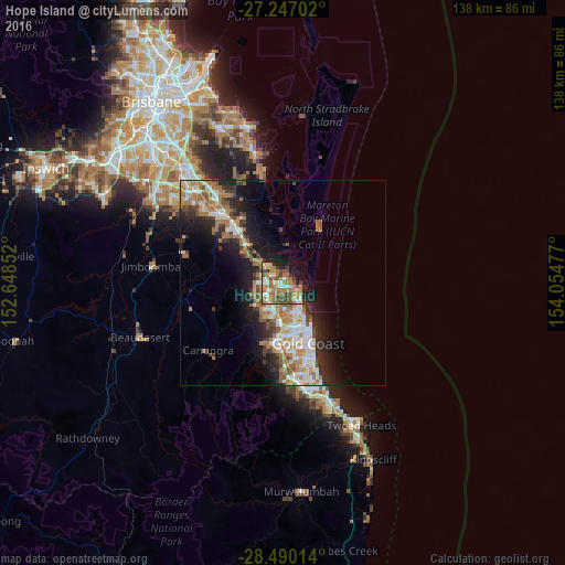
Analysis of Hope Island night lights 2016
Square area 10x10 km:
 6.82%
6.82%90-99
7.95%80-89
8.71%70-79
5.49%60-69
26.14%50-59
7.77%40-49
11.36%30-39
4.92%20-29
6.44%10-19
11.36%0-9
3.03%Square area 50x50 km:
2.91%90-99
3.11%80-89
1.64%70-79
1.52%60-69
5.94%50-59
1.98%40-49
2.01%30-39
2.41%20-29
4.4%10-19
9.01%0-9
65.07%Clear (daylight) street map image can be seen on geolist.org.
Map coordinates:
27° 14' 49.3" South, 152° 38' 54.7" East
27° 52' 13.3" South, 153° 21' 5.9" East
28° 29' 24.5" South, 154° 3' 17.2" East
Some cities around Hope Island sort by population:
• Upper Coomera
6.5 km =4 mi,  263°
263°
• Helensvale
5.6 km =3.5 mi,  199°
199°
• Coomera
3.3 km =2.1 mi,  337°
337°
• Oxenford
4.4 km =2.7 mi,  239°
239°
• Coombabah
4.9 km =3 mi,  157°
157°
• Arundel
7.6 km =4.7 mi,  171°
171°
• Runaway Bay
6.6 km =4.1 mi,  136°
136°
• Paradise Point
4.5 km =2.8 mi,  113°
113°
8310718 (p: 11,154)
Sources (retrieved 2019-11-25):
» Earth at Night: Flat Maps 2012, 2016