Runaway Bay night lights from space
Night Light of Runaway Bay (Queensland) from space (Australia) Src. Average luminocity for 10x10km area is 51.3542% and for 50x50km: 17.0332%.
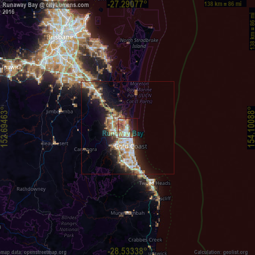
Analysis of Runaway Bay night lights 2016
Square area 10x10 km:
 7.39%
7.39%90-99
9.66%80-89
4.92%70-79
6.25%60-69
18.18%50-59
4.73%40-49
9.85%30-39
4.92%20-29
10.8%10-19
16.1%0-9
7.2%Square area 50x50 km:
2.88%90-99
3.08%80-89
1.54%70-79
1.3%60-69
5.24%50-59
1.87%40-49
1.9%30-39
2.23%20-29
4.29%10-19
8.94%0-9
66.71%Clear (daylight) street map image can be seen on geolist.org.
Map coordinates:
27° 17' 26.8" South, 152° 41' 40.7" East
27° 54' 49.9" South, 153° 23' 51.9" East
28° 32' 0.2" South, 154° 6' 3.2" East
Some cities around Runaway Bay sort by population:
• Southport
5.9 km =3.7 mi,  179°
179°
• Labrador
3.4 km =2.1 mi, 179°
• Helensvale
6.4 km =4 mi,  265°
265°
• Coombabah
2.7 km =1.7 mi,  277°
277°
• Arundel
4.3 km =2.7 mi,  232°
232°
• Biggera Waters
2.1 km =1.3 mi,  173°
173°
• Parkwood
5.7 km =3.5 mi,  216°
216°
• Paradise Point
3.1 km =1.9 mi,  351°
351°
8348932 (p: 8,970)
Sources (retrieved 2019-11-25):
» Earth at Night: Flat Maps 2012, 2016