Homebush West night lights from space
Night Light of Homebush West (New South Wales) from space (Australia) Src. Average luminocity for 10x10km area is 93.2255% and for 50x50km: 58.2484%.
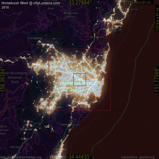
Analysis of Homebush West night lights 2016
Square area 10x10 km:
 32.69%
90-99
36.19%80-89
22.03%70-79
9.09%60-69
0%50-59
0%40-49
0%30-39
0%20-29
0%10-19
0%0-9
0%Square area 50x50 km:
13.33%90-99
14.78%80-89
7.74%70-79
9.22%60-69
10.8%50-59
5.56%40-49
3.76%30-39
5.56%20-29
7.29%10-19
10.32%0-9
11.64%Clear (daylight) street map image can be seen on geolist.org.
Map coordinates:
33° 16' 36.6" South, 150° 21' 49.8" East
33° 51' 45.7" South, 151° 4' 1.1" East
34° 26' 40.4" South, 151° 46' 12.3" East
Some cities around Homebush West sort by population:
• Auburn
3.4 km =2.1 mi,  294°
294°
• Strathfield
2.4 km =1.5 mi,  149°
149°
• Lidcombe
2.5 km =1.6 mi,  265°
265°
• Concord
3.8 km =2.4 mi,  63°
63°
• Berala
3.2 km =2 mi,  251°
251°
• Wentworth Point
3.6 km =2.2 mi,  10°
10°
• Concord West
2.4 km =1.5 mi,  47°
47°
• Newington
3.2 km =2 mi,  343°
343°
9972758 (p: 8,521)
Sources (retrieved 2019-11-25):
» Earth at Night: Flat Maps 2012, 2016