Berala night lights from space
Night Light of Berala (New South Wales) from space (Australia) Src. Average luminocity for 10x10km area is 94.5734% and for 50x50km: 60.184%.
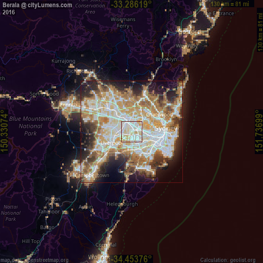
Analysis of Berala night lights 2016
Square area 10x10 km:
 37.94%
90-99
36.71%80-89
20.28%70-79
5.07%60-69
0%50-59
0%40-49
0%30-39
0%20-29
0%10-19
0%0-9
0%Square area 50x50 km:
13.77%90-99
15.13%80-89
7.88%70-79
9.59%60-69
11.28%50-59
5.93%40-49
4.15%30-39
5.8%20-29
7.96%10-19
9.49%0-9
9.01%Clear (daylight) street map image can be seen on geolist.org.
Map coordinates:
33° 17' 10.3" South, 150° 19' 50.7" East
33° 52' 19.1" South, 151° 2' 1.9" East
34° 27' 13.5" South, 151° 44' 13.2" East
Some cities around Berala sort by population:
• Auburn
2.4 km =1.5 mi,  358°
358°
• Greenacre
3.7 km =2.3 mi,  147°
147°
• Lidcombe
1 km =0.6 mi,  32°
32°
• Yagoona
3.9 km =2.4 mi,  199°
199°
• Chester Hill
3.3 km =2.1 mi,  256°
256°
• Homebush West
3.2 km =2 mi,  71°
71°
• Sefton
2.8 km =1.7 mi,  230°
230°
• South Granville
2.6 km =1.6 mi,  304°
304°
9972602 (p: 8,974)
Sources (retrieved 2019-11-25):
» Earth at Night: Flat Maps 2012, 2016