Newington night lights from space
Night Light of Newington (New South Wales) from space (Australia) Src. Average luminocity for 10x10km area is 92.4108% and for 50x50km: 58.3892%.
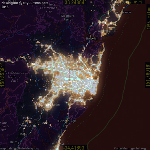
Analysis of Newington night lights 2016
Square area 10x10 km:
 33.04%
90-99
31.12%80-89
23.78%70-79
12.06%60-69
0%50-59
0%40-49
0%30-39
0%20-29
0%10-19
0%0-9
0%Square area 50x50 km:
13.28%90-99
14.77%80-89
7.71%70-79
9.37%60-69
10.92%50-59
5.57%40-49
3.95%30-39
5.69%20-29
7.48%10-19
9.12%0-9
12.14%Clear (daylight) street map image can be seen on geolist.org.
Map coordinates:
33° 14' 55.8" South, 150° 21' 14.1" East
33° 50' 5.6" South, 151° 3' 25.3" East
34° 25' 0.9" South, 151° 45' 36.6" East
Some cities around Newington sort by population:
• Auburn
2.8 km =1.7 mi,  232°
232°
• West Ryde
3.6 km =2.2 mi,  25°
25°
• Rhodes
3 km =1.9 mi,  72°
72°
• Ermington
2.2 km =1.4 mi,  354°
354°
• Homebush West
3.2 km =2 mi,  163°
163°
• Wentworth Point
1.7 km =1.1 mi, 74°
• Rydalmere
2.9 km =1.8 mi,  321°
321°
• Concord West
3.1 km =1.9 mi,  118°
118°
9972834 (p: 5,741)
Sources (retrieved 2019-11-25):
» Earth at Night: Flat Maps 2012, 2016