Hawthorn East night lights from space
Night Light of Hawthorn East (Victoria) from space (Australia) Src. Average luminocity for 10x10km area is 92.5391% and for 50x50km: 55.3555%.
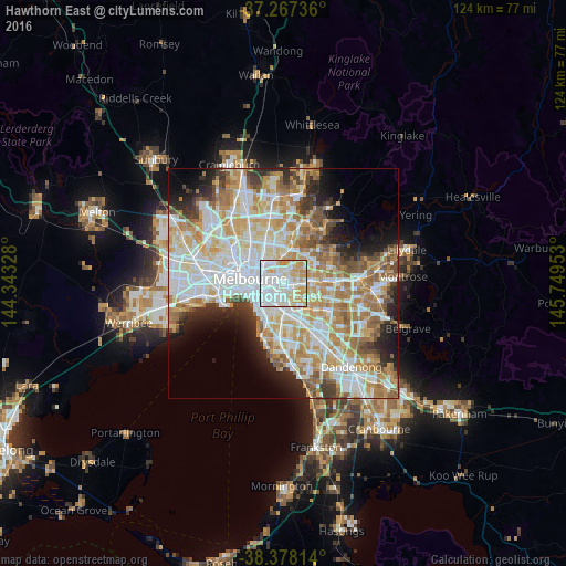
Analysis of Hawthorn East night lights 2016
Square area 10x10 km:
 40.31%
90-99
28.57%80-89
13.61%70-79
15.82%60-69
1.7%50-59
0%40-49
0%30-39
0%20-29
0%10-19
0%0-9
0%Square area 50x50 km:
14.95%90-99
13.77%80-89
6.91%70-79
9.67%60-69
8.38%50-59
5.68%40-49
3.82%30-39
3.46%20-29
5.63%10-19
6.4%0-9
21.33%Clear (daylight) street map image can be seen on geolist.org.
Map coordinates:
37° 16' 2.5" South, 144° 20' 35.8" East
37° 49' 29.4" South, 145° 2' 47" East
38° 22' 41.3" South, 145° 44' 58.3" East
Some cities around Hawthorn East sort by population:
• Richmond
4 km =2.5 mi,  280°
280°
• Kew
2.5 km =1.6 mi,  326°
326°
• Camberwell
2.8 km =1.7 mi,  133°
133°
• Glenferrie
1 km =0.6 mi,  161°
161°
• Balwyn
3.3 km =2.1 mi,  58°
58°
• Toorak
3.4 km =2.1 mi,  236°
236°
• Canterbury
3.4 km =2.1 mi,  89°
89°
• Kew East
3.1 km =1.9 mi,  12°
12°
7932627 (p: 14,097)
Sources (retrieved 2019-11-25):
» Earth at Night: Flat Maps 2012, 2016