Camberwell night lights from space
Night Light of Camberwell (Victoria) from space (Australia) Src. Average luminocity for 10x10km area is 90.3418% and for 50x50km: 54.2016%.

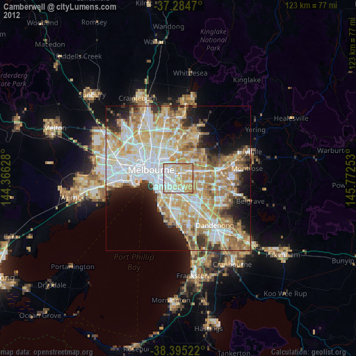
Analysis of Camberwell night lights 2016
Square area 10x10 km:
 30.1%
30.1%90-99
28.74%80-89
20.58%70-79
18.03%60-69
2.55%50-59
0%40-49
0%30-39
0%20-29
0%10-19
0%0-9
0%Square area 50x50 km:
14.33%90-99
13.39%80-89
6.75%70-79
9.33%60-69
8.26%50-59
5.92%40-49
3.93%30-39
3.67%20-29
5.48%10-19
6.93%0-9
22.01%Clear (daylight) street map image can be seen on geolist.org.
Map coordinates:
37° 17' 4.9" South, 144° 21' 58.6" East
37° 50' 31.4" South, 145° 4' 9.8" East
38° 23' 42.8" South, 145° 46' 21.1" East
Some cities around Camberwell sort by population:
• Glen Iris
2.7 km =1.7 mi,  185°
185°
• Hawthorn
3.8 km =2.4 mi,  309°
309°
• Hawthorn South
3 km =1.9 mi,  289°
289°
• Glenferrie
2 km =1.2 mi,  299°
299°
• Hawthorn East
2.8 km =1.7 mi, 313°
• Balwyn
3.8 km =2.4 mi,  12°
12°
• Canterbury
2.4 km =1.5 mi,  34°
34°
• Ashburton
3 km =1.9 mi,  155°
155°
2172686 (p: 21,744)
Sources (retrieved 2019-11-25):
» Earth at Night: Flat Maps 2012, 2016