Canterbury night lights from space
Night Light of Canterbury (Victoria) from space (Australia) Src. Average luminocity for 10x10km area is 86.7024% and for 50x50km: 53.3158%.
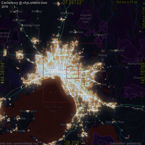
Analysis of Canterbury night lights 2016
Square area 10x10 km:
 18.88%
90-99
28.74%80-89
19.56%70-79
25.17%60-69
7.31%50-59
0.34%40-49
0%30-39
0%20-29
0%10-19
0%0-9
0%Square area 50x50 km:
13.87%90-99
13.1%80-89
6.52%70-79
9.46%60-69
8.12%50-59
5.73%40-49
3.89%30-39
3.78%20-29
5.79%10-19
7.1%0-9
22.63%Clear (daylight) street map image can be seen on geolist.org.
Map coordinates:
37° 16' 2" South, 144° 22' 53.9" East
37° 49' 28.9" South, 145° 5' 5.1" East
38° 22' 40.8" South, 145° 47' 16.4" East
Some cities around Canterbury sort by population:
• Camberwell
2.4 km =1.5 mi,  214°
214°
• Glenferrie
3.2 km =2 mi,  252°
252°
• Hawthorn East
3.4 km =2.1 mi,  269°
269°
• Surrey Hills
1.6 km =1 mi,  56°
56°
• Balwyn
1.8 km =1.1 mi,  343°
343°
• Box Hill
3.6 km =2.2 mi,  79°
79°
• Box Hill South
3.3 km =2.1 mi,  104°
104°
• Mont Albert North
3.4 km =2.1 mi,  37°
37°
7932625 (p: 7,926)
Sources (retrieved 2019-11-25):
» Earth at Night: Flat Maps 2012, 2016