Windsor night lights from space
Night Light of Windsor (Queensland) from space (Australia) Src. Average luminocity for 10x10km area is 94.75% and for 50x50km: 43.8183%.
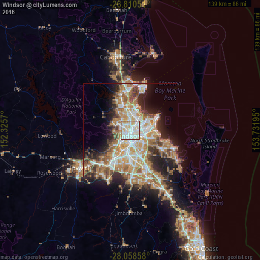
Analysis of Windsor night lights 2016
Square area 10x10 km:
 34.85%
90-99
40.34%80-89
21.78%70-79
3.03%60-69
0%50-59
0%40-49
0%30-39
0%20-29
0%10-19
0%0-9
0%Square area 50x50 km:
8.77%90-99
9.48%80-89
5.66%70-79
6.12%60-69
11.43%50-59
4.08%40-49
4.65%30-39
4.36%20-29
6.61%10-19
8.86%0-9
29.98%Clear (daylight) street map image can be seen on geolist.org.
Map coordinates:
26° 48' 37.8" South, 152° 19' 32.5" East
27° 26' 10.7" South, 153° 1' 43.8" East
28° 3' 30.9" South, 153° 43' 55" East
Some cities around Windsor sort by population:
• Kelvin Grove
2 km =1.2 mi,  229°
229°
• Fortitude Valley
2.3 km =1.4 mi,  172°
172°
• Spring Hill
2.8 km =1.7 mi,  191°
191°
• Bulimba
3.2 km =2 mi,  117°
117°
• Alderley
3 km =1.9 mi,  293°
293°
• Ascot
2.9 km =1.8 mi,  79°
79°
• Red Hill
3.2 km =2 mi,  235°
235°
• Teneriffe
2.8 km =1.7 mi,  140°
140°
6943579 (p: 6,983)
Sources (retrieved 2019-11-25):
» Earth at Night: Flat Maps 2012, 2016