Macquarie Fields night lights from space
Night Light of Macquarie Fields (New South Wales) from space (Australia) Src. Average luminocity for 10x10km area is 55.4528% and for 50x50km: 40.9504%.
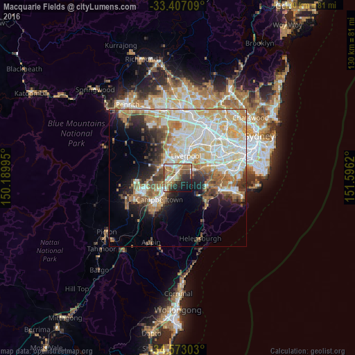
Analysis of Macquarie Fields night lights 2016
Square area 10x10 km:
 8.39%
8.39%90-99
9.62%80-89
7.17%70-79
6.99%60-69
16.61%50-59
12.24%40-49
4.55%30-39
5.24%20-29
12.59%10-19
12.59%0-9
4.02%Square area 50x50 km:
9.27%90-99
10.56%80-89
5.86%70-79
6.27%60-69
6.44%50-59
4.02%40-49
2.84%30-39
3.95%20-29
4.52%10-19
7.72%0-9
38.54%Clear (daylight) street map image can be seen on geolist.org.
Map coordinates:
33° 24' 25.5" South, 150° 11' 23.8" East
33° 59' 31.4" South, 150° 53' 35.1" East
34° 34' 22.9" South, 151° 35' 46.3" East
Some cities around Macquarie Fields sort by population:
• Casula
4.5 km =2.8 mi,  7°
7°
• Prestons
5.9 km =3.7 mi,  340°
340°
• Ingleburn
2.6 km =1.6 mi,  250°
250°
• Minto
6.1 km =3.8 mi,  220°
220°
• Glenfield
2.9 km =1.8 mi, 12°
• Lurnea
6.3 km =3.9 mi,  3°
3°
• Wattle Grove
6.3 km =3.9 mi,  48°
48°
• St Andrews
6.8 km =4.2 mi,  240°
240°
8348658 (p: 13,686)
Sources (retrieved 2019-11-25):
» Earth at Night: Flat Maps 2012, 2016