Prestons night lights from space
Night Light of Prestons (New South Wales) from space (Australia) Src. Average luminocity for 10x10km area is 76.1748% and for 50x50km: 46.5466%.
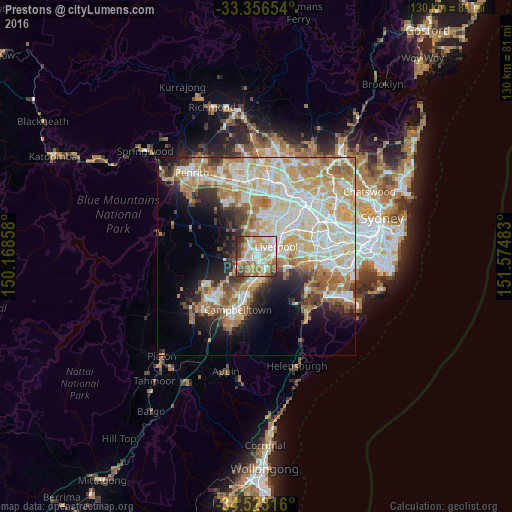
Analysis of Prestons night lights 2016
Square area 10x10 km:
 15.21%
90-99
21.85%80-89
12.41%70-79
13.81%60-69
14.69%50-59
8.74%40-49
4.02%30-39
6.64%20-29
2.62%10-19
0%0-9
0%Square area 50x50 km:
10.24%90-99
11.95%80-89
6.85%70-79
7.66%60-69
8.09%50-59
4.48%40-49
3.01%30-39
4.02%20-29
4.55%10-19
7.99%0-9
31.15%Clear (daylight) street map image can be seen on geolist.org.
Map coordinates:
33° 21' 23.5" South, 150° 10' 6.9" East
33° 56' 30.7" South, 150° 52' 18.1" East
34° 31' 23.4" South, 151° 34' 29.4" East
Some cities around Prestons sort by population:
• Casula
2.8 km =1.7 mi,  114°
114°
• Green Valley
4.3 km =2.7 mi,  354°
354°
• Hinchinbrook
2.7 km =1.7 mi,  342°
342°
• West Hoxton
3.7 km =2.3 mi,  283°
283°
• Mount Pritchard
5.3 km =3.3 mi,  35°
35°
• Glenfield
3.8 km =2.4 mi,  136°
136°
• Lurnea
2.4 km =1.5 mi,  72°
72°
• Middleton Grange
3.9 km =2.4 mi,  315°
315°
8347914 (p: 15,312)
Sources (retrieved 2019-11-25):
» Earth at Night: Flat Maps 2012, 2016