Alexandria night lights from space
Night Light of Alexandria (New South Wales) from space (Australia) Src. Average luminocity for 10x10km area is 95.2308% and for 50x50km: 41.6657%.
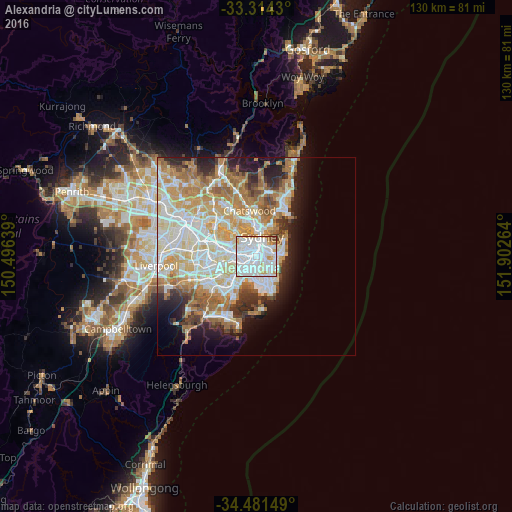
Analysis of Alexandria night lights 2016
Square area 10x10 km:
 55.07%
90-99
30.42%80-89
4.02%70-79
6.29%60-69
1.92%50-59
0.52%40-49
1.75%30-39
0%20-29
0%10-19
0%0-9
0%Square area 50x50 km:
10.04%90-99
10.79%80-89
5.36%70-79
6.66%60-69
7.71%50-59
3.61%40-49
2.49%30-39
3.23%20-29
4.72%10-19
7.02%0-9
38.38%Clear (daylight) street map image can be seen on geolist.org.
Map coordinates:
33° 18' 51.5" South, 150° 29' 47" East
33° 53' 59.6" South, 151° 11' 58.2" East
34° 28' 53.4" South, 151° 54' 9.5" East
Some cities around Alexandria sort by population:
• Surry Hills
2.2 km =1.4 mi,  34°
34°
• Newtown
2 km =1.2 mi,  274°
274°
• Redfern
0.9 km =0.6 mi, 28°
• Camperdown
2.4 km =1.5 mi,  298°
298°
• Zetland
1.2 km =0.7 mi,  135°
135°
• Haymarket
2.4 km =1.5 mi,  12°
12°
• Chippendale
1.5 km =0.9 mi,  352°
352°
• Erskineville
1.3 km =0.8 mi,  256°
256°
2178136 (p: 8,075)
Sources (retrieved 2019-11-25):
» Earth at Night: Flat Maps 2012, 2016