Croydon night lights from space
Night Light of Croydon (New South Wales) from space (Australia) Src. Average luminocity for 10x10km area is 92.8462% and for 50x50km: 52.5449%.
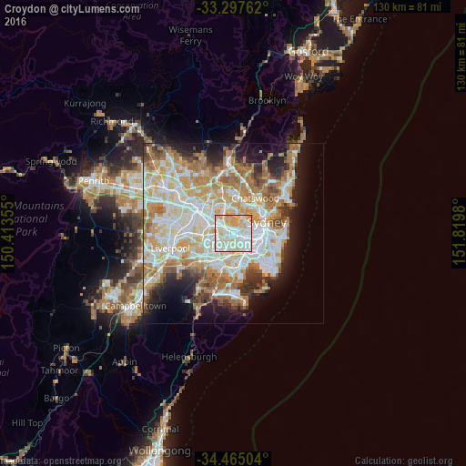
Analysis of Croydon night lights 2016
Square area 10x10 km:
 34.79%
90-99
32.87%80-89
20.98%70-79
11.36%60-69
0%50-59
0%40-49
0%30-39
0%20-29
0%10-19
0%0-9
0%Square area 50x50 km:
12.44%90-99
13.63%80-89
7.25%70-79
8.47%60-69
9.42%50-59
4.74%40-49
2.95%30-39
3.9%20-29
5.71%10-19
9.34%0-9
22.15%Clear (daylight) street map image can be seen on geolist.org.
Map coordinates:
33° 17' 51.4" South, 150° 24' 48.8" East
33° 52' 60" South, 151° 7' 0" East
34° 27' 54.1" South, 151° 49' 11.3" East
Some cities around Croydon sort by population:
• Strathfield
3.4 km =2.1 mi,  274°
274°
• Ashfield
0.8 km =0.5 mi,  134°
134°
• Burwood
1.5 km =0.9 mi, 270°
• Dulwich Hill
3.1 km =1.9 mi,  137°
137°
• Five Dock
2.1 km =1.3 mi,  32°
32°
• Summer Hill
2.2 km =1.4 mi,  114°
114°
• Canterbury
3.2 km =2 mi,  176°
176°
• Haberfield
2.5 km =1.6 mi,  89°
89°
2169868 (p: 10,546)
Sources (retrieved 2019-11-25):
» Earth at Night: Flat Maps 2012, 2016