Canterbury night lights from space
Night Light of Canterbury (New South Wales) from space (Australia) Src. Average luminocity for 10x10km area is 95.3811% and for 50x50km: 50.352%.
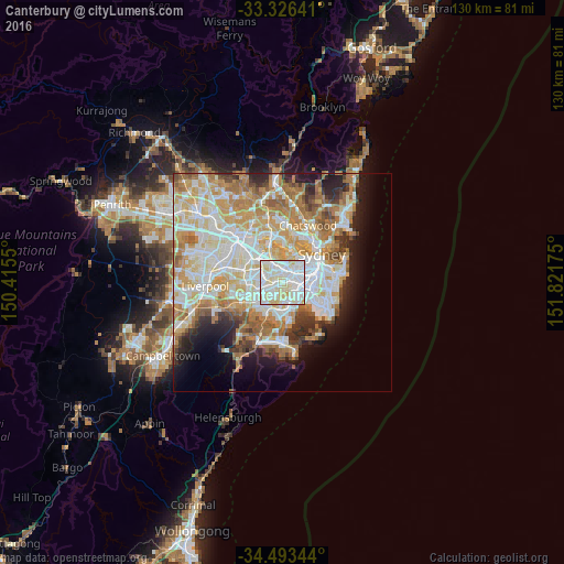
Analysis of Canterbury night lights 2016
Square area 10x10 km:
 40.38%
90-99
38.64%80-89
19.58%70-79
1.4%60-69
0%50-59
0%40-49
0%30-39
0%20-29
0%10-19
0%0-9
0%Square area 50x50 km:
12.29%90-99
13.42%80-89
7.09%70-79
8.22%60-69
8.68%50-59
4.33%40-49
2.7%30-39
3.36%20-29
4.9%10-19
7.04%0-9
27.97%Clear (daylight) street map image can be seen on geolist.org.
Map coordinates:
33° 19' 35.1" South, 150° 24' 55.8" East
33° 54' 42.9" South, 151° 7' 7" East
34° 29' 36.4" South, 151° 49' 18.3" East
Some cities around Canterbury sort by population:
• Campsie
1.5 km =0.9 mi,  267°
267°
• Ashfield
2.6 km =1.6 mi,  8°
8°
• Earlwood
1.2 km =0.7 mi,  149°
149°
• Dulwich Hill
2.1 km =1.3 mi,  65°
65°
• Belmore
2.8 km =1.7 mi,  253°
253°
• Croydon
3.2 km =2 mi,  356°
356°
• Summer Hill
2.9 km =1.8 mi,  38°
38°
• Belfield
3.3 km =2.1 mi,  286°
286°
6949377 (p: 7,200)
Sources (retrieved 2019-11-25):
» Earth at Night: Flat Maps 2012, 2016