Dulwich Hill night lights from space
Night Light of Dulwich Hill (New South Wales) from space (Australia) Src. Average luminocity for 10x10km area is 95.8846% and for 50x50km: 48.386%.
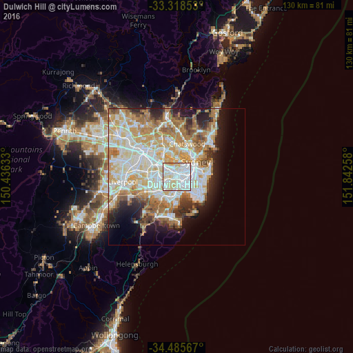
Analysis of Dulwich Hill night lights 2016
Square area 10x10 km:
 48.95%
90-99
32.87%80-89
15.91%70-79
2.27%60-69
0%50-59
0%40-49
0%30-39
0%20-29
0%10-19
0%0-9
0%Square area 50x50 km:
11.87%90-99
12.83%80-89
6.75%70-79
7.74%60-69
8.28%50-59
4.1%40-49
2.66%30-39
3.37%20-29
5.08%10-19
7.32%0-9
30%Clear (daylight) street map image can be seen on geolist.org.
Map coordinates:
33° 19' 6.7" South, 150° 26' 10.8" East
33° 54' 14.8" South, 151° 8' 22" East
34° 29' 8.4" South, 151° 50' 33.3" East
Some cities around Dulwich Hill sort by population:
• Marrickville
1.5 km =0.9 mi,  103°
103°
• Ashfield
2.3 km =1.4 mi,  318°
318°
• Earlwood
2.3 km =1.4 mi,  215°
215°
• Petersham
1.8 km =1.1 mi,  53°
53°
• Stanmore
2.5 km =1.6 mi,  64°
64°
• Summer Hill
1.4 km =0.9 mi,  355°
355°
• Canterbury
2.1 km =1.3 mi,  245°
245°
• Haberfield
2.4 km =1.5 mi,  9°
9°
8348836 (p: 13,536)
Sources (retrieved 2019-11-25):
» Earth at Night: Flat Maps 2012, 2016