Burwood night lights from space
Night Light of Burwood (New South Wales) from space (Australia) Src. Average luminocity for 10x10km area is 92.9493% and for 50x50km: 54.5996%.
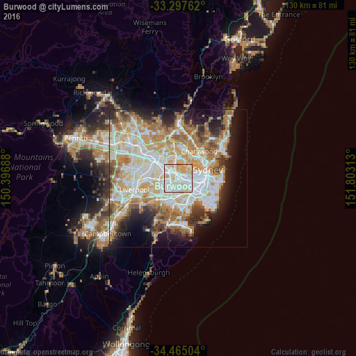
Analysis of Burwood night lights 2016
Square area 10x10 km:
 34.09%
90-99
33.22%80-89
23.43%70-79
9.27%60-69
0%50-59
0%40-49
0%30-39
0%20-29
0%10-19
0%0-9
0%Square area 50x50 km:
12.8%90-99
14.19%80-89
7.41%70-79
8.8%60-69
9.84%50-59
5.19%40-49
3.21%30-39
4.15%20-29
5.95%10-19
9.39%0-9
19.07%Clear (daylight) street map image can be seen on geolist.org.
Map coordinates:
33° 17' 51.4" South, 150° 23' 48.8" East
33° 52' 60" South, 151° 6' 0" East
34° 27' 54.1" South, 151° 48' 11.3" East
Some cities around Burwood sort by population:
• Strathfield
1.9 km =1.2 mi,  278°
278°
• Campsie
3.3 km =2.1 mi,  175°
175°
• Ashfield
2.2 km =1.4 mi,  104°
104°
• Croydon
1.5 km =0.9 mi,  90°
90°
• Five Dock
3.2 km =2 mi,  56°
56°
• Summer Hill
3.6 km =2.2 mi, 104°
• Homebush
2.4 km =1.5 mi,  320°
320°
• Belfield
2.7 km =1.7 mi,  212°
212°
2172995 (p: 15,935)
Sources (retrieved 2019-11-25):
» Earth at Night: Flat Maps 2012, 2016