Cremorne night lights from space
Night Light of Cremorne (New South Wales) from space (Australia) Src. Average luminocity for 10x10km area is 74.6783% and for 50x50km: 38.4786%.
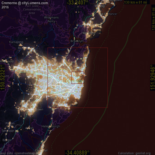
Analysis of Cremorne night lights 2016
Square area 10x10 km:
 16.43%
90-99
18.18%80-89
6.99%70-79
14.34%60-69
21.15%50-59
10.14%40-49
5.59%30-39
6.29%20-29
0.87%10-19
0%0-9
0%Square area 50x50 km:
9%90-99
9.62%80-89
4.7%70-79
6.31%60-69
7.57%50-59
3.4%40-49
2.31%30-39
3.39%20-29
4.5%10-19
7.08%0-9
42.12%Clear (daylight) street map image can be seen on geolist.org.
Map coordinates:
33° 14' 26.5" South, 150° 31' 23.6" East
33° 49' 36.4" South, 151° 13' 34.8" East
34° 24' 32" South, 151° 55' 46.1" East
Some cities around Cremorne sort by population:
• Mosman
1.8 km =1.1 mi,  138°
138°
• Neutral Bay
1.5 km =0.9 mi,  213°
213°
• North Sydney
2.2 km =1.4 mi,  232°
232°
• Seaforth
3.1 km =1.9 mi,  23°
23°
• Cammeray
1.1 km =0.7 mi,  302°
302°
• St Leonards
2.6 km =1.6 mi,  278°
278°
• Northbridge
1.7 km =1.1 mi,  331°
331°
• Naremburn
2.6 km =1.6 mi,  294°
294°
2207879 (p: 11,069)
Sources (retrieved 2019-11-25):
» Earth at Night: Flat Maps 2012, 2016