Cranbourne night lights from space
Night Light of Cranbourne (Victoria) from space (Australia) Src. Average luminocity for 10x10km area is 54.3344% and for 50x50km: 26.2931%.
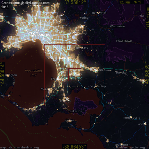
Analysis of Cranbourne night lights 2016
Square area 10x10 km:
 7.79%
7.79%90-99
8.6%80-89
6.17%70-79
12.18%60-69
12.66%50-59
8.44%40-49
4.71%30-39
10.71%20-29
11.69%10-19
15.75%0-9
1.3%Square area 50x50 km:
4.31%90-99
4.99%80-89
2.41%70-79
5.03%60-69
4.72%50-59
4.43%40-49
3.31%30-39
3.14%20-29
4.47%10-19
10.81%0-9
52.4%Clear (daylight) street map image can be seen on geolist.org.
Map coordinates:
37° 33' 29.2" South, 144° 34' 48.5" East
38° 6' 48.3" South, 145° 16' 59.7" East
38° 39' 52.3" South, 145° 59' 11" East
Some cities around Cranbourne sort by population:
• Narre Warren South
7.8 km =4.8 mi,  5°
5°
• Narre Warren
9 km =5.6 mi, 9°
• Hampton Park
9.4 km =5.8 mi,  341°
341°
• Carrum Downs
9.8 km =6.1 mi,  278°
278°
• Lynbrook
6.8 km =4.2 mi, 339°
• Clyde North
4.4 km =2.7 mi,  94°
94°
• Skye
5.9 km =3.7 mi, 279°
• Beaconsfield
10.1 km =6.3 mi,  45°
45°
2170079 (p: 19,825)
Sources (retrieved 2019-11-25):
» Earth at Night: Flat Maps 2012, 2016