Clifton Springs night lights from space
Night Light of Clifton Springs (Victoria) from space (Australia) Src. Average luminocity for 10x10km area is 5.2483% and for 50x50km: 7.7325%.
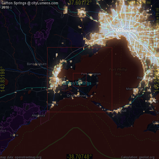
Analysis of Clifton Springs night lights 2016
Square area 10x10 km:
 0%
0%90-99
0%80-89
0%70-79
1.7%60-69
1.02%50-59
0%40-49
0.85%30-39
4.42%20-29
1.53%10-19
0.51%0-9
89.97%Square area 50x50 km:
0.71%90-99
0.78%80-89
0.32%70-79
1.93%60-69
1.25%50-59
1.1%40-49
1.42%30-39
1.16%20-29
2.13%10-19
5.89%0-9
83.32%Clear (daylight) street map image can be seen on geolist.org.
Map coordinates:
37° 36' 6.2" South, 143° 51' 7.1" East
38° 9' 24.1" South, 144° 33' 18.4" East
38° 42' 26.9" South, 145° 15' 29.6" East
Some cities around Clifton Springs sort by population:
• Geelong
17 km =10.6 mi,  273°
273°
• Corio
17.1 km =10.6 mi,  298°
298°
• Grovedale
18.6 km =11.6 mi,  254°
254°
• Ocean Grove
11.7 km =7.3 mi,  195°
195°
• Leopold
8.4 km =5.2 mi,  243°
243°
• Norlane
18.6 km =11.6 mi,  289°
289°
• Geelong West
18.2 km =11.3 mi,  276°
276°
• Geelong city centre
16.9 km =10.5 mi, 272°
2171320 (p: 7,264)
Sources (retrieved 2019-11-25):
» Earth at Night: Flat Maps 2012, 2016