Corio night lights from space
Night Light of Corio (Victoria) from space (Australia) Src. Average luminocity for 10x10km area is 43.4188% and for 50x50km: 8.2014%.
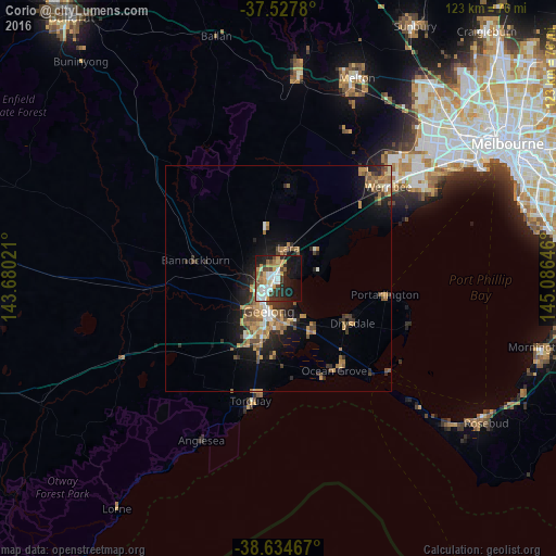
Analysis of Corio night lights 2016
Square area 10x10 km:
 8.77%
8.77%90-99
8.93%80-89
1.62%70-79
8.77%60-69
6.17%50-59
3.9%40-49
5.52%30-39
7.14%20-29
11.04%10-19
24.19%0-9
13.96%Square area 50x50 km:
0.74%90-99
0.83%80-89
0.46%70-79
2.05%60-69
1.47%50-59
1.38%40-49
1.46%30-39
1.1%20-29
2.21%10-19
5.48%0-9
82.84%Clear (daylight) street map image can be seen on geolist.org.
Map coordinates:
37° 31' 40.1" South, 143° 40' 48.8" East
38° 4' 60" South, 144° 22' 60" East
38° 38' 4.8" South, 145° 5' 11.3" East
Some cities around Corio sort by population:
• Geelong
7.4 km =4.6 mi,  195°
195°
• Lara
6.9 km =4.3 mi,  16°
16°
• Belmont
10.8 km =6.7 mi, 199°
• Newtown
8.9 km =5.5 mi,  208°
208°
• Norlane
3.2 km =2 mi,  231°
231°
• Geelong West
6.9 km =4.3 mi, 206°
• Hamlyn Heights
6.4 km =4 mi, 229°
• Geelong city centre
7.6 km =4.7 mi,  194°
194°
2170307 (p: 15,215)
Sources (retrieved 2019-11-25):
» Earth at Night: Flat Maps 2012, 2016