Ocean Grove night lights from space
Night Light of Ocean Grove (Victoria) from space (Australia) Src. Average luminocity for 10x10km area is 7.4116% and for 50x50km: 6.8701%.
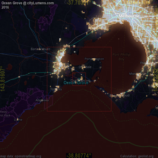
Analysis of Ocean Grove night lights 2016
Square area 10x10 km:
 0%
0%90-99
0%80-89
0%70-79
2.55%60-69
2.21%50-59
2.04%40-49
0.68%30-39
1.02%20-29
3.06%10-19
0.51%0-9
87.93%Square area 50x50 km:
0.68%90-99
0.72%80-89
0.32%70-79
1.81%60-69
1.08%50-59
1.02%40-49
1.21%30-39
1.11%20-29
1.97%10-19
4.43%0-9
85.65%Clear (daylight) street map image can be seen on geolist.org.
Map coordinates:
37° 42' 12.6" South, 143° 48' 57.9" East
38° 15' 27.8" South, 144° 31' 9.1" East
38° 48' 27.9" South, 145° 13' 20.4" East
Some cities around Ocean Grove sort by population:
• Geelong
18.5 km =11.5 mi,  311°
311°
• Grovedale
16.1 km =10 mi,  293°
293°
• Belmont
18 km =11.2 mi,  300°
300°
• Torquay
18.7 km =11.6 mi,  244°
244°
• Leopold
8.7 km =5.4 mi,  329°
329°
• Newtown
19.8 km =12.3 mi, 305°
• Clifton Springs
11.7 km =7.3 mi,  15°
15°
• Geelong city centre
18.2 km =11.3 mi, 311°
12069926 (p: 13,523)
Sources (retrieved 2019-11-25):
» Earth at Night: Flat Maps 2012, 2016