Geelong city centre night lights from space
Night Light of Geelong city centre (Victoria) from space (Australia) Src. Average luminocity for 10x10km area is 56.6429% and for 50x50km: 7.3101%.
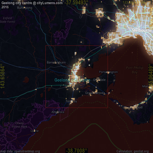
Analysis of Geelong city centre night lights 2016
Square area 10x10 km:
 9.18%
9.18%90-99
9.86%80-89
4.25%70-79
14.46%60-69
9.52%50-59
9.86%40-49
9.18%30-39
8.33%20-29
13.78%10-19
11.56%0-9
0%Square area 50x50 km:
0.71%90-99
0.78%80-89
0.32%70-79
1.86%60-69
1.19%50-59
1.05%40-49
1.3%30-39
1.04%20-29
2.03%10-19
4.95%0-9
84.76%Clear (daylight) street map image can be seen on geolist.org.
Map coordinates:
37° 35' 41.7" South, 143° 39' 31.1" East
38° 8' 59.9" South, 144° 21' 42.3" East
38° 42' 2.9" South, 145° 3' 53.6" East
Some cities around Geelong city centre sort by population:
• Highton
5 km =3.1 mi,  242°
242°
• Corio
7.6 km =4.7 mi,  14°
14°
• Grovedale
5.7 km =3.5 mi,  190°
190°
• Belmont
3.2 km =2 mi,  210°
210°
• Newtown
2.4 km =1.5 mi,  259°
259°
• Norlane
5.4 km =3.4 mi,  352°
352°
• Hamlyn Heights
4.4 km =2.7 mi,  317°
317°
• Waurn Ponds
10.1 km =6.3 mi,  222°
222°
11523841 (p: 5,881)
Sources (retrieved 2019-11-25):
» Earth at Night: Flat Maps 2012, 2016