Leopold night lights from space
Night Light of Leopold (Victoria) from space (Australia) Src. Average luminocity for 10x10km area is 10.6327% and for 50x50km: 7.375%.
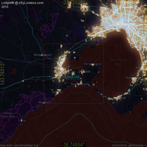
Analysis of Leopold night lights 2016
Square area 10x10 km:
 0.34%
0.34%90-99
0.34%80-89
0%70-79
3.74%60-69
1.02%50-59
0.85%40-49
3.91%30-39
0.51%20-29
0.85%10-19
11.56%0-9
76.87%Square area 50x50 km:
0.71%90-99
0.78%80-89
0.32%70-79
1.86%60-69
1.22%50-59
1.11%40-49
1.29%30-39
1.11%20-29
2.09%10-19
4.9%0-9
84.61%Clear (daylight) street map image can be seen on geolist.org.
Map coordinates:
37° 38' 7" South, 143° 45' 54.5" East
38° 11' 24" South, 144° 28' 5.7" East
38° 44' 25.9" South, 145° 10' 17" East
Some cities around Leopold sort by population:
• Geelong
10.5 km =6.5 mi,  296°
296°
• Grovedale
10.4 km =6.5 mi,  263°
263°
• Belmont
11.1 km =6.9 mi,  278°
278°
• Ocean Grove
8.7 km =5.4 mi,  149°
149°
• Newtown
12.3 km =7.6 mi,  289°
289°
• Clifton Springs
8.4 km =5.2 mi,  63°
63°
• Geelong West
11.9 km =7.4 mi, 298°
• Geelong city centre
10.3 km =6.4 mi, 295°
2160336 (p: 12,389)
Sources (retrieved 2019-11-25):
» Earth at Night: Flat Maps 2012, 2016