Floreat night lights from space
Night Light of Floreat (Western Australia) from space (Australia) Src. Average luminocity for 10x10km area is 77.6573% and for 50x50km: 41.7337%.
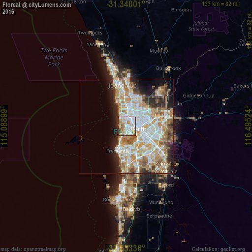
Analysis of Floreat night lights 2016
Square area 10x10 km:
 25.7%
25.7%90-99
23.43%80-89
8.39%70-79
10.31%60-69
13.29%50-59
2.8%40-49
1.75%30-39
1.92%20-29
12.24%10-19
0.17%0-9
0%Square area 50x50 km:
9.64%90-99
10.52%80-89
4.98%70-79
6.67%60-69
8.02%50-59
4.48%40-49
2.93%30-39
2.92%20-29
5.98%10-19
6.63%0-9
37.24%Clear (daylight) street map image can be seen on geolist.org.
Map coordinates:
31° 20' 24" South, 115° 5' 20.4" East
31° 56' 19" South, 115° 47' 31.6" East
32° 32' 0.1" South, 116° 29' 42.9" East
Some cities around Floreat sort by population:
• Wembley
2.5 km =1.6 mi,  75°
75°
• Subiaco
3.5 km =2.2 mi,  108°
108°
• Doubleview
4.8 km =3 mi,  348°
348°
• Claremont
4.7 km =2.9 mi,  191°
191°
• Mount Hawthorn
4.6 km =2.9 mi,  62°
62°
• City Beach
2.9 km =1.8 mi,  279°
279°
• Wembley Downs
3.5 km =2.2 mi,  329°
329°
• West Perth
4.8 km =3 mi,  103°
103°
8349363 (p: 7,695)
Sources (retrieved 2019-11-25):
» Earth at Night: Flat Maps 2012, 2016