City Beach night lights from space
Night Light of City Beach (Western Australia) from space (Australia) Src. Average luminocity for 10x10km area is 56.4021% and for 50x50km: 39.9397%.
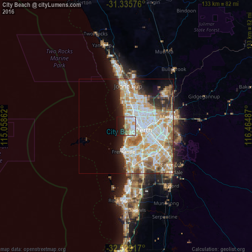
Analysis of City Beach night lights 2016
Square area 10x10 km:
 15.03%
90-99
15.56%80-89
5.07%70-79
7.69%60-69
11.89%50-59
1.75%40-49
1.4%30-39
2.27%20-29
14.34%10-19
15.21%0-9
9.79%Square area 50x50 km:
9.56%90-99
10.4%80-89
4.99%70-79
6.68%60-69
7.47%50-59
3.82%40-49
2.45%30-39
2.26%20-29
5.06%10-19
5.19%0-9
42.11%Clear (daylight) street map image can be seen on geolist.org.
Map coordinates:
31° 20' 8.7" South, 115° 3' 31" East
31° 56' 3.8" South, 115° 45' 42.3" East
32° 31' 45" South, 116° 27' 53.5" East
Some cities around City Beach sort by population:
• Scarborough
4.3 km =2.7 mi,  3°
3°
• Wembley
5.3 km =3.3 mi,  88°
88°
• Subiaco
6.3 km =3.9 mi,  104°
104°
• Doubleview
4.6 km =2.9 mi,  23°
23°
• Claremont
5.4 km =3.4 mi,  158°
158°
• Innaloo
5.6 km =3.5 mi,  34°
34°
• Floreat
2.9 km =1.8 mi, 99°
• Wembley Downs
2.8 km =1.7 mi, 23°
10035407 (p: 6,443)
Sources (retrieved 2019-11-25):
» Earth at Night: Flat Maps 2012, 2016