Holland Park West night lights from space
Night Light of Holland Park West (Queensland) from space (Australia) Src. Average luminocity for 10x10km area is 89.6151% and for 50x50km: 45.7773%.
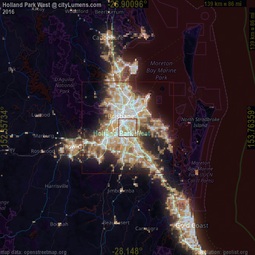
Analysis of Holland Park West night lights 2016
Square area 10x10 km:
 26.79%
90-99
28.57%80-89
18.85%70-79
24.21%60-69
1.59%50-59
0%40-49
0%30-39
0%20-29
0%10-19
0%0-9
0%Square area 50x50 km:
8.82%90-99
9.62%80-89
5.66%70-79
6.54%60-69
12.24%50-59
3.91%40-49
4.5%30-39
4.82%20-29
8.14%10-19
11.95%0-9
23.79%Clear (daylight) street map image can be seen on geolist.org.
Map coordinates:
26° 54' 3.5" South, 152° 21' 26.4" East
27° 31' 34.5" South, 153° 3' 37.7" East
28° 8' 52.8" South, 153° 45' 48.9" East
Some cities around Holland Park West sort by population:
• Coorparoo
3.7 km =2.3 mi,  356°
356°
• Mount Gravatt East
2.7 km =1.7 mi,  126°
126°
• Annerley
3.2 km =2 mi,  299°
299°
• Tarragindi
1.5 km =0.9 mi,  266°
266°
• Moorooka
3.6 km =2.2 mi,  255°
255°
• Greenslopes
2.3 km =1.4 mi,  331°
331°
• Carina Heights
3.7 km =2.3 mi,  55°
55°
• Salisbury
3.9 km =2.4 mi,  224°
224°
8348561 (p: 6,266)
Sources (retrieved 2019-11-25):
» Earth at Night: Flat Maps 2012, 2016