Mansfield night lights from space
Night Light of Mansfield (Queensland) from space (Australia) Src. Average luminocity for 10x10km area is 77.4464% and for 50x50km: 44.618%.
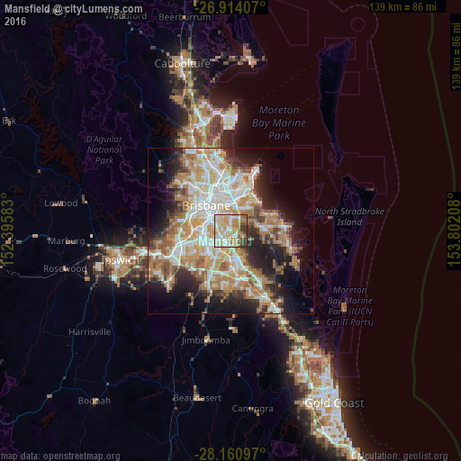
Analysis of Mansfield night lights 2016
Square area 10x10 km:
 14.29%
90-99
18.45%80-89
16.87%70-79
21.43%60-69
12.5%50-59
3.57%40-49
6.35%30-39
6.15%20-29
0.4%10-19
0%0-9
0%Square area 50x50 km:
8.7%90-99
9.58%80-89
5.53%70-79
6.47%60-69
11.72%50-59
3.7%40-49
4.13%30-39
4.38%20-29
7.63%10-19
11.78%0-9
26.37%Clear (daylight) street map image can be seen on geolist.org.
Map coordinates:
26° 54' 50.7" South, 152° 23' 45" East
27° 32' 21.4" South, 153° 5' 56.2" East
28° 9' 39.5" South, 153° 48' 7.5" East
Some cities around Mansfield sort by population:
• Carindale
3.7 km =2.3 mi,  5°
5°
• Mount Gravatt East
1.7 km =1.1 mi,  265°
265°
• Wishart
1.7 km =1.1 mi,  172°
172°
• Upper Mount Gravatt
2.8 km =1.7 mi,  210°
210°
• Holland Park
4 km =2.5 mi,  308°
308°
• Carina Heights
3.6 km =2.2 mi,  347°
347°
• Holland Park West
4.1 km =2.5 mi,  290°
290°
• Macgregor
4.3 km =2.7 mi,  228°
228°
9957346 (p: 8,588)
Sources (retrieved 2019-11-25):
» Earth at Night: Flat Maps 2012, 2016