Greenslopes night lights from space
Night Light of Greenslopes (Queensland) from space (Australia) Src. Average luminocity for 10x10km area is 91.3631% and for 50x50km: 46.1197%.
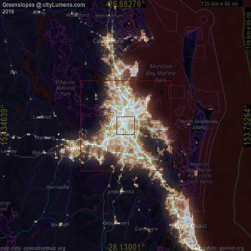
Analysis of Greenslopes night lights 2016
Square area 10x10 km:
 29.56%
90-99
31.94%80-89
19.05%70-79
19.44%60-69
0%50-59
0%40-49
0%30-39
0%20-29
0%10-19
0%0-9
0%Square area 50x50 km:
8.87%90-99
9.67%80-89
5.67%70-79
6.55%60-69
12.5%50-59
4.12%40-49
4.7%30-39
4.98%20-29
8.08%10-19
10.92%0-9
23.95%Clear (daylight) street map image can be seen on geolist.org.
Map coordinates:
26° 52' 57.9" South, 152° 20' 47" East
27° 30' 29.3" South, 153° 2' 58.2" East
28° 7' 48" South, 153° 45' 9.5" East
Some cities around Greenslopes sort by population:
• Coorparoo
1.9 km =1.2 mi,  27°
27°
• Annerley
1.7 km =1.1 mi,  254°
254°
• Camp Hill
3.1 km =1.9 mi,  58°
58°
• Tarragindi
2.1 km =1.3 mi,  190°
190°
• Holland Park
2 km =1.2 mi,  119°
119°
• Woolloongabba
2.5 km =1.6 mi,  329°
329°
• Holland Park West
2.3 km =1.4 mi,  151°
151°
• East Brisbane
3.1 km =1.9 mi,  349°
349°
9957342 (p: 9,197)
Sources (retrieved 2019-11-25):
» Earth at Night: Flat Maps 2012, 2016