Burwood East night lights from space
Night Light of Burwood East (Victoria) from space (Australia) Src. Average luminocity for 10x10km area is 79.4594% and for 50x50km: 49.4745%.
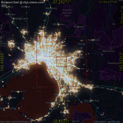
Analysis of Burwood East night lights 2016
Square area 10x10 km:
 13.47%
90-99
16.88%80-89
14.29%70-79
27.92%60-69
21.92%50-59
5.36%40-49
0.16%30-39
0%20-29
0%10-19
0%0-9
0%Square area 50x50 km:
12.46%90-99
11.66%80-89
6.23%70-79
8.88%60-69
7.96%50-59
5.94%40-49
3.89%30-39
3.19%20-29
4.66%10-19
7.35%0-9
27.77%Clear (daylight) street map image can be seen on geolist.org.
Map coordinates:
37° 17' 33.8" South, 144° 26' 48.8" East
37° 51' 0" South, 145° 9' 0" East
38° 24' 11.2" South, 145° 51' 11.3" East
Some cities around Burwood East sort by population:
• Glen Waverley
3.4 km =2.1 mi,  157°
157°
• Mount Waverley
3.5 km =2.2 mi,  210°
210°
• Blackburn
3.5 km =2.2 mi,  4°
4°
• Nunawading
3.9 km =2.4 mi,  31°
31°
• Vermont South
3 km =1.9 mi,  106°
106°
• Forest Hill
3.5 km =2.2 mi,  57°
57°
• Blackburn South
1.2 km =0.7 mi,  22°
22°
• Box Hill South
3.2 km =2 mi,  307°
307°
2172994 (p: 10,125)
Sources (retrieved 2019-11-25):
» Earth at Night: Flat Maps 2012, 2016