Blackburn South night lights from space
Night Light of Blackburn South (Victoria) from space (Australia) Src. Average luminocity for 10x10km area is 78.8929% and for 50x50km: 48.6027%.
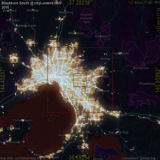
Analysis of Blackburn South night lights 2016
Square area 10x10 km:
 12.93%
90-99
16.84%80-89
13.78%70-79
26.02%60-69
23.64%50-59
6.63%40-49
0.17%30-39
0%20-29
0%10-19
0%0-9
0%Square area 50x50 km:
12.2%90-99
11.43%80-89
6.04%70-79
8.81%60-69
7.83%50-59
5.9%40-49
3.76%30-39
3.31%20-29
4.55%10-19
7.33%0-9
28.86%Clear (daylight) street map image can be seen on geolist.org.
Map coordinates:
37° 16' 56.6" South, 144° 27' 8.5" East
37° 50' 23.1" South, 145° 9' 19.8" East
38° 23' 34.6" South, 145° 51' 31" East
Some cities around Blackburn South sort by population:
• Burwood
3.4 km =2.1 mi,  250°
250°
• Box Hill
3.5 km =2.2 mi,  311°
311°
• Nunawading
2.6 km =1.6 mi,  35°
35°
• Vermont South
3.1 km =1.9 mi,  129°
129°
• Forest Hill
2.5 km =1.6 mi,  73°
73°
• Vermont
3.4 km =2.1 mi,  83°
83°
• Burwood East
1.2 km =0.7 mi,  202°
202°
• Box Hill South
3.1 km =1.9 mi,  285°
285°
7932634 (p: 10,616)
Sources (retrieved 2019-11-25):
» Earth at Night: Flat Maps 2012, 2016