Box Hill night lights from space
Night Light of Box Hill (Victoria) from space (Australia) Src. Average luminocity for 10x10km area is 81.5425% and for 50x50km: 50.794%.
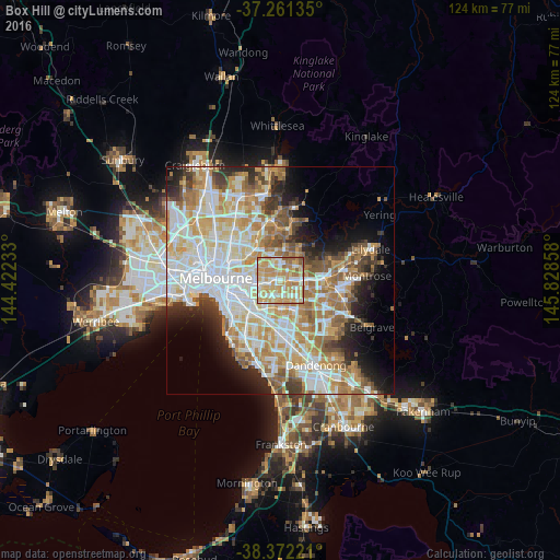
Analysis of Box Hill night lights 2016
Square area 10x10 km:
 11.05%
90-99
22.28%80-89
19.22%70-79
29.08%60-69
13.95%50-59
4.08%40-49
0.34%30-39
0%20-29
0%10-19
0%0-9
0%Square area 50x50 km:
13.11%90-99
12.28%80-89
6.23%70-79
9.1%60-69
7.74%50-59
5.61%40-49
3.75%30-39
3.5%20-29
5.54%10-19
7.25%0-9
25.89%Clear (daylight) street map image can be seen on geolist.org.
Map coordinates:
37° 15' 40.9" South, 144° 25' 20.4" East
37° 49' 7.9" South, 145° 7' 31.6" East
38° 22' 20" South, 145° 49' 42.9" East
Some cities around Box Hill sort by population:
• Doncaster
3.4 km =2.1 mi,  357°
357°
• Burwood
3.5 km =2.2 mi,  189°
189°
• Blackburn
2.4 km =1.5 mi,  90°
90°
• Surrey Hills
2.2 km =1.4 mi,  276°
276°
• Blackburn South
3.5 km =2.2 mi,  131°
131°
• Canterbury
3.6 km =2.2 mi,  259°
259°
• Blackburn North
2.5 km =1.6 mi,  65°
65°
• Mont Albert North
2.5 km =1.6 mi,  323°
323°
2174360 (p: 11,792)
Sources (retrieved 2019-11-25):
» Earth at Night: Flat Maps 2012, 2016