Sefton night lights from space
Night Light of Sefton (New South Wales) from space (Australia) Src. Average luminocity for 10x10km area is 93.1783% and for 50x50km: 59.9421%.
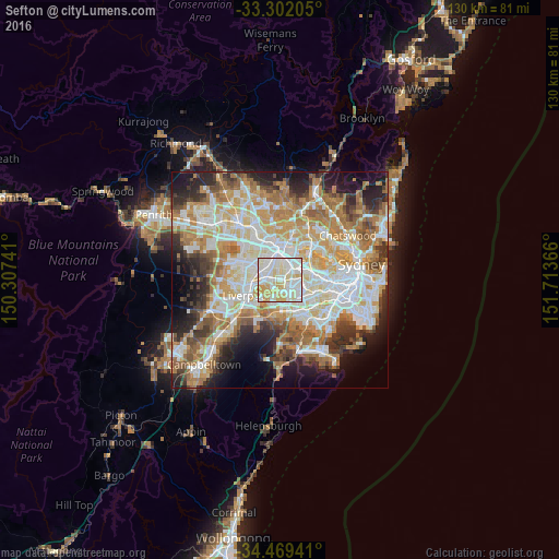
Analysis of Sefton night lights 2016
Square area 10x10 km:
 31.47%
90-99
38.46%80-89
20.1%70-79
9.97%60-69
0%50-59
0%40-49
0%30-39
0%20-29
0%10-19
0%0-9
0%Square area 50x50 km:
13.9%90-99
15.01%80-89
7.78%70-79
9.62%60-69
11.11%50-59
5.99%40-49
4.25%30-39
5.81%20-29
7.6%10-19
8.81%0-9
10.13%Clear (daylight) street map image can be seen on geolist.org.
Map coordinates:
33° 18' 7.4" South, 150° 18' 26.7" East
33° 53' 15.8" South, 151° 0' 37.9" East
34° 28' 9.9" South, 151° 42' 49.2" East
Some cities around Sefton sort by population:
• Lidcombe
3.7 km =2.3 mi,  46°
46°
• Yagoona
2.1 km =1.3 mi,  155°
155°
• Chester Hill
1.4 km =0.9 mi,  313°
313°
• Bass Hill
1.8 km =1.1 mi,  229°
229°
• Georges Hall
3.1 km =1.9 mi,  220°
220°
• Berala
2.8 km =1.7 mi, 50°
• Villawood
2.8 km =1.7 mi,  277°
277°
• South Granville
3.2 km =2 mi,  0°
0°
8347677 (p: 5,757)
Sources (retrieved 2019-11-25):
» Earth at Night: Flat Maps 2012, 2016