Belfield night lights from space
Night Light of Belfield (New South Wales) from space (Australia) Src. Average luminocity for 10x10km area is 94.3129% and for 50x50km: 54.8864%.
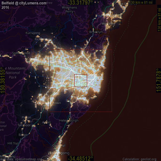
Analysis of Belfield night lights 2016
Square area 10x10 km:
 34.97%
90-99
37.94%80-89
24.3%70-79
2.8%60-69
0%50-59
0%40-49
0%30-39
0%20-29
0%10-19
0%0-9
0%Square area 50x50 km:
12.99%90-99
14.4%80-89
7.49%70-79
9%60-69
9.79%50-59
5.09%40-49
3.27%30-39
4.25%20-29
5.63%10-19
7.86%0-9
20.25%Clear (daylight) street map image can be seen on geolist.org.
Map coordinates:
33° 19' 4.7" South, 150° 22' 53.6" East
33° 54' 12.7" South, 151° 5' 4.8" East
34° 29' 6.4" South, 151° 47' 16.1" East
Some cities around Belfield sort by population:
• Strathfield
2.5 km =1.6 mi,  349°
349°
• Campsie
1.9 km =1.2 mi,  120°
120°
• Greenacre
2.7 km =1.7 mi,  277°
277°
• Lakemba
2 km =1.2 mi,  204°
204°
• Burwood
2.7 km =1.7 mi,  32°
32°
• Belmore
1.8 km =1.1 mi,  165°
165°
• Wiley Park
2.8 km =1.7 mi,  214°
214°
• Canterbury
3.3 km =2.1 mi,  106°
106°
9972601 (p: 6,295)
Sources (retrieved 2019-11-25):
» Earth at Night: Flat Maps 2012, 2016