Lakemba night lights from space
Night Light of Lakemba (New South Wales) from space (Australia) Src. Average luminocity for 10x10km area is 93.3794% and for 50x50km: 54.7558%.
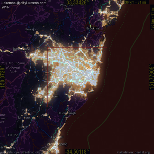
Analysis of Lakemba night lights 2016
Square area 10x10 km:
 28.5%
28.5%90-99
40.91%80-89
26.57%70-79
3.5%60-69
0.52%50-59
0%40-49
0%30-39
0%20-29
0%10-19
0%0-9
0%Square area 50x50 km:
13.18%90-99
14.52%80-89
7.57%70-79
8.84%60-69
9.59%50-59
4.98%40-49
3.2%30-39
4.43%20-29
5.12%10-19
7.09%0-9
21.47%Clear (daylight) street map image can be seen on geolist.org.
Map coordinates:
33° 20' 3.3" South, 150° 22' 22.1" East
33° 55' 11" South, 151° 4' 33.3" East
34° 30' 4.2" South, 151° 46' 44.6" East
Some cities around Lakemba sort by population:
• Campsie
2.6 km =1.6 mi,  72°
72°
• Greenacre
2.9 km =1.8 mi,  319°
319°
• Punchbowl
2.5 km =1.6 mi,  245°
245°
• Belmore
1.2 km =0.7 mi,  86°
86°
• Roselands
1.5 km =0.9 mi,  189°
189°
• Wiley Park
0.9 km =0.6 mi,  237°
237°
• Belfield
2 km =1.2 mi,  24°
24°
• Narwee
3 km =1.9 mi, 191°
2160744 (p: 16,921)
Sources (retrieved 2019-11-25):
» Earth at Night: Flat Maps 2012, 2016