Noranda night lights from space
Night Light of Noranda (Western Australia) from space (Australia) Src. Average luminocity for 10x10km area is 85.1685% and for 50x50km: 39.4223%.
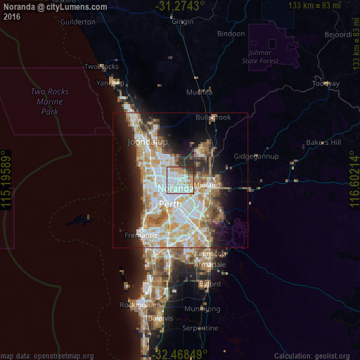
Analysis of Noranda night lights 2016
Square area 10x10 km:
 27.66%
90-99
31.87%80-89
6.96%70-79
16.3%60-69
6.96%50-59
1.47%40-49
3.66%30-39
4.03%20-29
1.1%10-19
0%0-9
0%Square area 50x50 km:
9.09%90-99
9.98%80-89
4.59%70-79
6.18%60-69
6.86%50-59
3.91%40-49
2.52%30-39
3.3%20-29
6.14%10-19
8.52%0-9
38.91%Clear (daylight) street map image can be seen on geolist.org.
Map coordinates:
31° 16' 27.5" South, 115° 11' 45.2" East
31° 52' 24" South, 115° 53' 56.4" East
32° 28' 6.6" South, 116° 36' 7.7" East
Some cities around Noranda sort by population:
• Dianella
3.1 km =1.9 mi,  237°
237°
• Morley
1.9 km =1.2 mi,  147°
147°
• Ballajura
3.7 km =2.3 mi,  354°
354°
• Beechboro
3.7 km =2.3 mi,  75°
75°
• Mirrabooka
3.5 km =2.2 mi,  295°
295°
• Inglewood
5.1 km =3.2 mi,  200°
200°
• Bedford
4.3 km =2.7 mi,  192°
192°
• Bennett Springs
4.6 km =2.9 mi,  70°
70°
8348087 (p: 7,853)
Sources (retrieved 2019-11-25):
» Earth at Night: Flat Maps 2012, 2016