Altona night lights from space
Night Light of Altona (Victoria) from space (Australia) Src. Average luminocity for 10x10km area is 61.5795% and for 50x50km: 42.9887%.
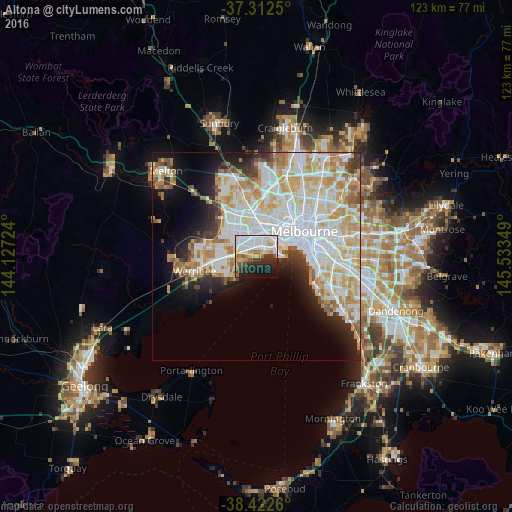
Analysis of Altona night lights 2016
Square area 10x10 km:
 23.05%
90-99
15.26%80-89
3.57%70-79
6.17%60-69
5.84%50-59
4.87%40-49
2.44%30-39
7.63%20-29
15.26%10-19
12.5%0-9
3.41%Square area 50x50 km:
12.99%90-99
11.19%80-89
5.86%70-79
6.6%60-69
4.56%50-59
3.03%40-49
2.08%30-39
2.49%20-29
4.7%10-19
8.25%0-9
38.26%Clear (daylight) street map image can be seen on geolist.org.
Map coordinates:
37° 18' 45" South, 144° 7' 38.1" East
37° 52' 10.7" South, 144° 49' 49.3" East
38° 25' 21.4" South, 145° 32' 0.6" East
Some cities around Altona sort by population:
• Point Cook
8.6 km =5.3 mi,  234°
234°
• Yarraville
8.5 km =5.3 mi,  46°
46°
• Williamstown
6.1 km =3.8 mi,  83°
83°
• Newport
5.6 km =3.5 mi,  59°
59°
• Williams Landing
7.7 km =4.8 mi,  276°
276°
• Seabrook
6.4 km =4 mi,  258°
258°
• Seddon
8.8 km =5.5 mi,  36°
36°
• Laverton
5.4 km =3.4 mi, 279°
2177992 (p: 10,563)
Sources (retrieved 2019-11-25):
» Earth at Night: Flat Maps 2012, 2016