Laverton night lights from space
Night Light of Laverton (Victoria) from space (Australia) Src. Average luminocity for 10x10km area is 80.4935% and for 50x50km: 36.1994%.
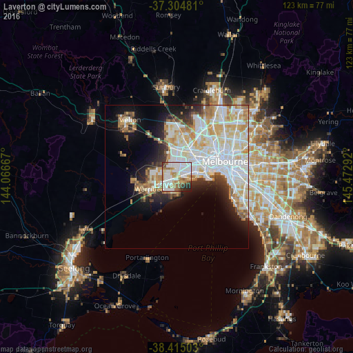
Analysis of Laverton night lights 2016
Square area 10x10 km:
 33.6%
33.6%90-99
20.78%80-89
6.66%70-79
7.14%60-69
12.18%50-59
6.01%40-49
3.57%30-39
3.73%20-29
5.36%10-19
0.97%0-9
0%Square area 50x50 km:
11.66%90-99
9.2%80-89
4.53%70-79
4.69%60-69
3.56%50-59
2.61%40-49
2.03%30-39
2.21%20-29
4.27%10-19
8.27%0-9
46.96%Clear (daylight) street map image can be seen on geolist.org.
Map coordinates:
37° 18' 17.3" South, 144° 4' 0" East
37° 51' 43.2" South, 144° 46' 11.2" East
38° 24' 54.1" South, 145° 28' 22.5" East
Some cities around Laverton sort by population:
• Point Cook
6.1 km =3.8 mi,  195°
195°
• Hoppers Crossing
6.5 km =4 mi,  249°
249°
• Truganina
5.3 km =3.3 mi,  340°
340°
• Altona Meadows
2.7 km =1.7 mi,  153°
153°
• Altona North
7.4 km =4.6 mi,  66°
66°
• Altona
5.4 km =3.4 mi,  99°
99°
• Williams Landing
2.3 km =1.4 mi,  270°
270°
• Seabrook
2.3 km =1.4 mi, 204°
2207598 (p: 5,001)
Sources (retrieved 2019-11-25):
» Earth at Night: Flat Maps 2012, 2016