Williams Landing night lights from space
Night Light of Williams Landing (Victoria) from space (Australia) Src. Average luminocity for 10x10km area is 80.6997% and for 50x50km: 33.2233%.
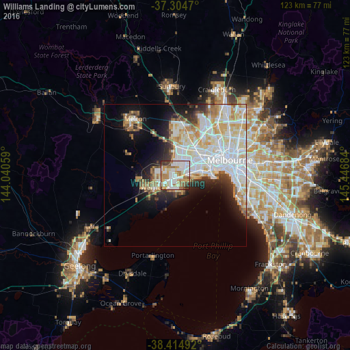
Analysis of Williams Landing night lights 2016
Square area 10x10 km:
 29.55%
90-99
20.45%80-89
7.14%70-79
10.88%60-69
14.94%50-59
5.84%40-49
4.38%30-39
5.19%20-29
1.62%10-19
0%0-9
0%Square area 50x50 km:
10.87%90-99
8.19%80-89
3.98%70-79
4.22%60-69
3.15%50-59
2.42%40-49
2.04%30-39
2.19%20-29
4.19%10-19
8.12%0-9
50.63%Clear (daylight) street map image can be seen on geolist.org.
Map coordinates:
37° 18' 16.9" South, 144° 2' 26.1" East
37° 51' 42.8" South, 144° 44' 37.4" East
38° 24' 53.7" South, 145° 26' 48.6" East
Some cities around Williams Landing sort by population:
• Point Cook
5.9 km =3.7 mi,  173°
173°
• Hoppers Crossing
4.5 km =2.8 mi,  238°
238°
• Tarneit
7.9 km =4.9 mi,  291°
291°
• Truganina
5.1 km =3.2 mi,  6°
6°
• Altona Meadows
4.3 km =2.7 mi,  125°
125°
• Altona
7.7 km =4.8 mi,  96°
96°
• Seabrook
2.5 km =1.6 mi,  148°
148°
• Laverton
2.3 km =1.4 mi,  90°
90°
8643474 (p: 6,607)
Sources (retrieved 2019-11-25):
» Earth at Night: Flat Maps 2012, 2016